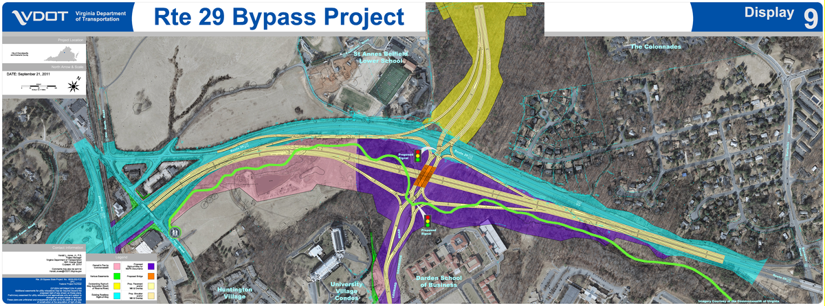
Preliminary design of the “southern terminus” of the Route 29 Charlottesville Bypass with the Rivanna Trail inserted.
Bypass is light yellow. Rivanna Trail is green.

Dear Friends of the Rivanna Trail,
The RTF is grateful to generous landowners who have given permission to the public to walk on trails on their land, and we include in this list the Virginia Department of Transportation (VDOT). In our capacity as stewards of the land our trails traverse, the RTF has historically not made public statements about land use issues, but we wish to inform our members of the impact VDOT’s proposed Route 29 Charlottesville Bypass will have on the Rivanna Trail.
Specifically the “southern terminus” of the proposed Bypass will lie near, along, or on the path of the Rivanna Trail behind UVa’s JAG, Law, and Business schools, from near Barracks Road to Ivy Road. As currently designed, the southern terminus has the potential to close off access to trail users permanently.
We invite you to read the following information:
VDOT’s website about the Bypass -
http://www.virginiadot.org/projects/culpeper/rt._29_bypass.asp
On the above website, scroll down to
Southern Terminus Concept Drawing, Sept. 26, 2011 (6 MB) to see the preliminary design of the “southern terminus” in the vicinity affecting the Rivanna Trail.
On the above website, scroll down to “Skanska-Branch/JMT Technical Proposal, June 20, 2012” to see other preliminary designs of the Bypass.
Proposal Submittal - Volume 1 and 2 (28 MB)
On the above VDOT website, find the environmental assessment under
New Environmental assessment Aug. 23, 2012 (4 MB).
What you can do:
Attend VDOT’s public information meeting about designs for the Bypass. Thursday, September 27th from 6 - 9 p.m. at Jack Jouett Middle School.
Encourage VDOT to include the Rivanna Trail in their designs of the Bypass, to accommodate hikers and bikers in the region of the Bypass, and to protect trails.
Information about alternatives to the Bypass:
The Southern Environmental Law Center (SELC) has created a plan entitled “LetsGo 29” that brings together ideas that could be implemented in the Route 29 corridor, projects that done together would cost less money than VDOT’s Bypass and that would not impact the Rivanna Trail.
SELC’s information:
http://www.southernenvironment.org/cases/charlottesville_bypass/
SELC’s LetsGo 29 video:
http://www.southernenvironment.org/lets_go_29
A bit of historical background:
SELC’s “LetsGo 29” plan references “Places 29 Master Plan.” This latter document encompasses the Route 29 corridor and includes multiple spot transportation improvements. The Places 29 Master Plan, created with public participation, was adopted by both the Albemarle County planning commission and the Board of Supervisors.
Information and documents:
http://www.albemarle.org/department.asp?department=cdd&relpage=3735